posted August 17, 2014 09:58 AM


A MAPMAKER USES CENSUS DATA TO SHOW WHERE PEOPLE ARE, AND WHERE THEY ARE NOT. THE OVERLAP WILL SURPRISE YOU.A full 47% of the country remains desolate--unoccupied by even a single inhabitant. A map by Nik Freeman details where in America people don't live by shading in uninhabited census blocks--the smallest unit the U.S. Census Bureau uses to keep track of who lives where.
At first glance, the map reveals what you'd expect: areas where nature still runs wild. You can see the green outline of the Mississippi River and feel awe at the harsh desert that bellies across the western half of the U.S. Rugged, much-loved protected areas, including national parks such as the Everglades, are clearly defined, too.
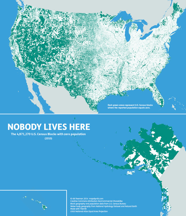
Is it really possible that Manifest Destiny didn't conquer as much of the continent's wilderness as we thought it did? Let's crunch the visual numbers. It turns out that not all the green space is nature! Infrastructure--highways, city parks, shopping malls, and warehouses--count as unoccupied, too. (Feel cheated yet?) Those places are easier to see in the eastern half of the U.S., where the larger blocks of inhabited space provide enough contrast for you to see the outlines of highways, rivers, and lakes.
"Human geographers spend so much time thinking about where people are," Freeman writes on his blog. "I thought I might bring some new insight by showing where they are not, adding contrast and context to the typical displays of the country�s population geography."
It's pretty much exactly how Californians see the rest of America, right? Does Maine even exist?
http://www.fastcodesign.com/3029339/infographic-of-the-day/the-us-is-sti ll-47-percent-frontier-sort-of
 Lindaland


 UBBFriend: Email This Page to Someone!